
Scoped photogrammetry
Mapping + 3D Site Models
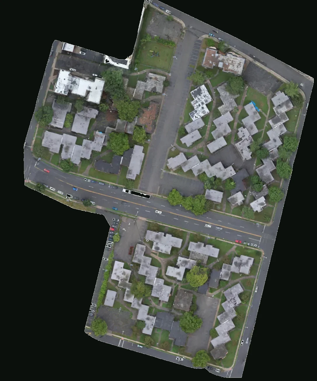
Planned overlapping capture for orthomosaics, photogrammetry, and 3D site models when the decision needs measured context — not just a pretty frame. The sample is Kuzuri Kijiji, East Orange: the 1973 townhouse complex at 19 Freeway Drive East, mapped July 6, 2026.
01
Brief
We collect the mission goal, the site, and the window from you first. A listing still, a month-over-month jobsite set, a claim file, a roof packet, and an orthomosaic are five different flights. Where and when matter as much as what.
02
Authorize
Airspace class, LAANC on the live UAS Facility Map, Part 107 Waivers, TFR and National Security Event notices, and local permits (NYPD for New York City operations, property/GC access, venue clearance). Coordination happens here — not on the pad.
03
Conditions
Day-of weather, TFRs, National Security Events, and NOTAMs can change an approval that looked clean the night before. This is the GO / NO-GO gate. Authorization is planning status, not a launch.
04
Fly
Capture from the viewpoints the brief and the authorization actually allow — stills, film, or a mapping grid. The aircraft comes down when the coverage for the deliverable is in the card, not when the battery is empty.
05
Process
After the flight: cull, color, align, and reconstruct. Photogrammetry, 3D site models, construction tracking sets, and inspection packets are built here. The deliverable is prepared for the client’s review workflow.
06
Deliver
Stills, film, orthomosaics, DEMs, 3D models, progress comparisons, and reports — organized to the specification in the brief. This is the product the client files, presents, or sells. Flying is only half the job.
Planned around the operating need
Useful visual context, with clear boundaries.
Planned overlapping capture for orthomosaics, photogrammetry, and 3D site models when the decision needs measured context — not just a pretty frame. The sample is Kuzuri Kijiji, East Orange: the 1973 townhouse complex at 19 Freeway Drive East, mapped July 6, 2026.
Built for Survey-adjacent teams, GCs, and planners who need site geometry. Every assignment begins with the decision the media needs to support, the site, access, requested timing, and intended output.
Typical deliverables
- Orthomosaic
- DEM / elevation context
- 3D site model
- Camera-station / coverage report
- Source frames
Photogrammetry, on Kuzuri Kijiji
Pattern is a decision — not a style filter.
Compare illustrative nadir, crosshatch, and orbit patterns over the Kuzuri Kijiji orthomosaic. The animated paths explain capture choices; they are not recorded flight telemetry. The source map shows the site as captured.
Flight pattern
Nadir lawnmower
The aircraft flies parallel lines with the camera pointed straight down. High overlap is what lets software stitch a measured map. Rooftops and pavement read clearly; walls do not.
- Overlap / capture
- Typically 75% front / 70% side
- What you get
- Orthomosaic, DSM/DEM, weak facades
Ground texture is the July 6, 2026 orthomosaic of Kuzuri Kijiji, East Orange — a real Baron Aerial Media mapping site, shown at the end of this illustrative capture sequence. Switch patterns to see how the path changes what the reconstructor can solve.
Process, not a pretty JPEG
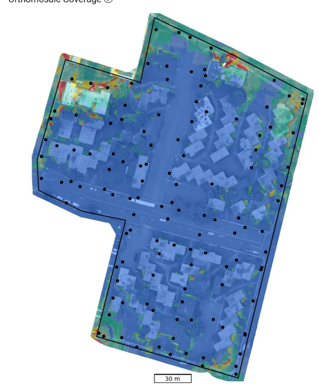
Coverage across the site.
After the flight, overlapping frames are aligned. The source coverage visualization helps explain how imagery covers the site. This is what a mapping deliverable can include alongside the orthomosaic — so a GC or planner can see how the model was built, not just the flattened map.
Selected sample
Kuzuri Kijiji, East Orange
Townhouses, parking and access roads recorded as an orthomosaic, with separate elevation and coverage visualizations.
Mapping
Kuzuri Kijiji, East Orange
Townhouses, parking and access roads recorded as an orthomosaic, with separate elevation and coverage visualizations.
Open the case study →Other paths
All capabilities →
Altitude Changes Everything
From Rooftops to Bottom Lines.
Tell us the site and the decision the media has to support. We will scope the flight, the deliverables, and whether it is operationally feasible under Part 107.
Plan a Drone Mission